 |
| A large erratic with many naturally made cracks and splits. This, however caught my eye and held up at every angle. |
Friday, December 25, 2015
Boulder Art
Thursday, December 24, 2015
Notched Stones
Standing by a pile of sones, facing due East, on a knoll overlooking a large swamp, I spot a short, notched, squarish stone. Turning around, facing west: another notched, squarish stone.
In 6 months time I'll come back here to see if they mark the East-West equinox Sunrise and Sunset.
In-between photographing the two rocks, I was distracted by an old Bent Tree. (See next post.)


In 6 months time I'll come back here to see if they mark the East-West equinox Sunrise and Sunset.
In-between photographing the two rocks, I was distracted by an old Bent Tree. (See next post.)


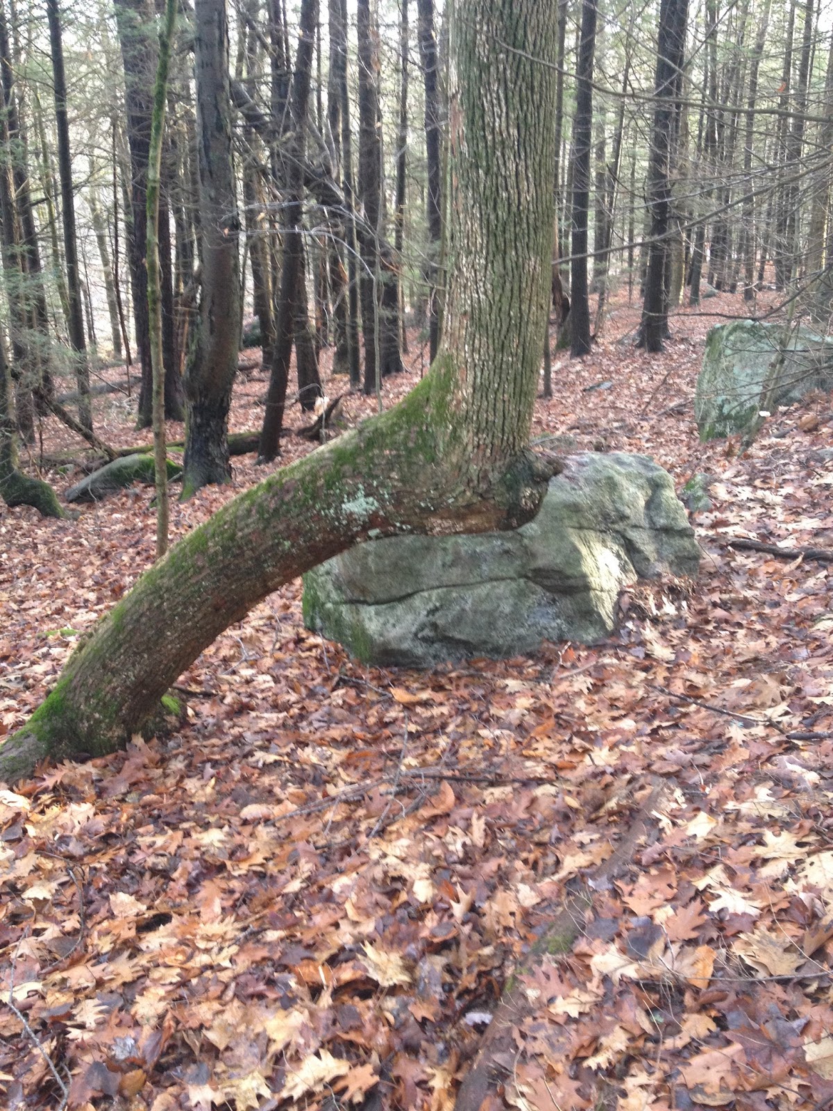
Another Bent Tree pointing West, towards The Lake.
Follow the link above for information which helps explain why there are
Bent Trail Trees in this area which could still be alive...but just barely.
This Bent Tree is located 1/2 mile east of the Long Trial, on the top of a knoll. I didn't notice at the time, but there is another bent tree just visible on the far left side in the top photo...at around 9 o'clock. I shall go back to see if it is natural or man made. This location is a knoll overlooking a swamp which serves as the headwaters of the Manhan River.
The Indians who roamed and hunted in these hills were Algonquins.


 |
Monday, December 21, 2015
Large Rock Shelter
 |
| A very large erratic; the top has split off and is leaning on the lower half, about 12 feet tall, creating a "cave." There are couple of large loose rocks filling in the split at the top, between the two boulders. Piles of animal "scat" suggest years of animal occupation ; No "back door." It appears that a 3rd piece of the original boulder has been pulled down, effectively blocking the west side. |
Rock Designs
 |
| Three small rocks placed on end. The middle one "points" east to a spring. |
 |
| Three rocks arranged on the ground, with quartz on lower left, facing west. |
 |
| An interesting arrangement on the ground, leaning on a side hill, facing west. Note the small rock on the right shoulder which echo's the larger "body" shape. Head at top. |
 |
| Arrangement of rocks on the ground. "Head" at the top. Quartz in the center. Facing west. The arrangements on the ground, like this one, are most in danger of being run over by The Logging Operation, which will resume in the Spring of 2016. The pink tape that I've used to mark many of them has gone missing. |
Rock on Rock, placed
 |
| Boulder with rock near edge, and a much small piece of quartz. |
 |
| Boulder with 2 rocks. |
 |
| Boulder with four rocks in a row. |
 |
| Boulder with six rocks lined up across the top. |
 |
| Boulder with 4 rocks. |
 |
| Large boulder with round rock and piece of quartz. |
 |
| Large boulder with long flat rock perched on top. |
 |
| Boulder with square rock, and one to the left, looking like a turtle's head. |
 |
| Boulder with assorted rocks and several pieces of quartz. |
Butterfly Quartz
 |
| What looks like two quartz rocks on the left, (9 o'clock) is really one, joined at the center, each the size of a man's fist. It is placed on a rock pile; the root of a Hemlock is working it's way over and in-between. There is a 2nd constructed pile (below, )located about 1/2 mile away, with a similar butterfly shaped quartz.  |
Sunday, December 20, 2015

December 21 Sunset
December 20th: Today was a bit clearer than on the 10th, so even though the sun wasn't casting strong shadows, the weather was nice and I wanted to check the Trail Camera, so
I walked up on The Hill at sunset.
I tried to sit in the same spot as on the 10th.
 Something didn't line up. Things felt a bit off. Had the sun started to move back north?
Thursday, December 10, 2015
Earliest Sunset

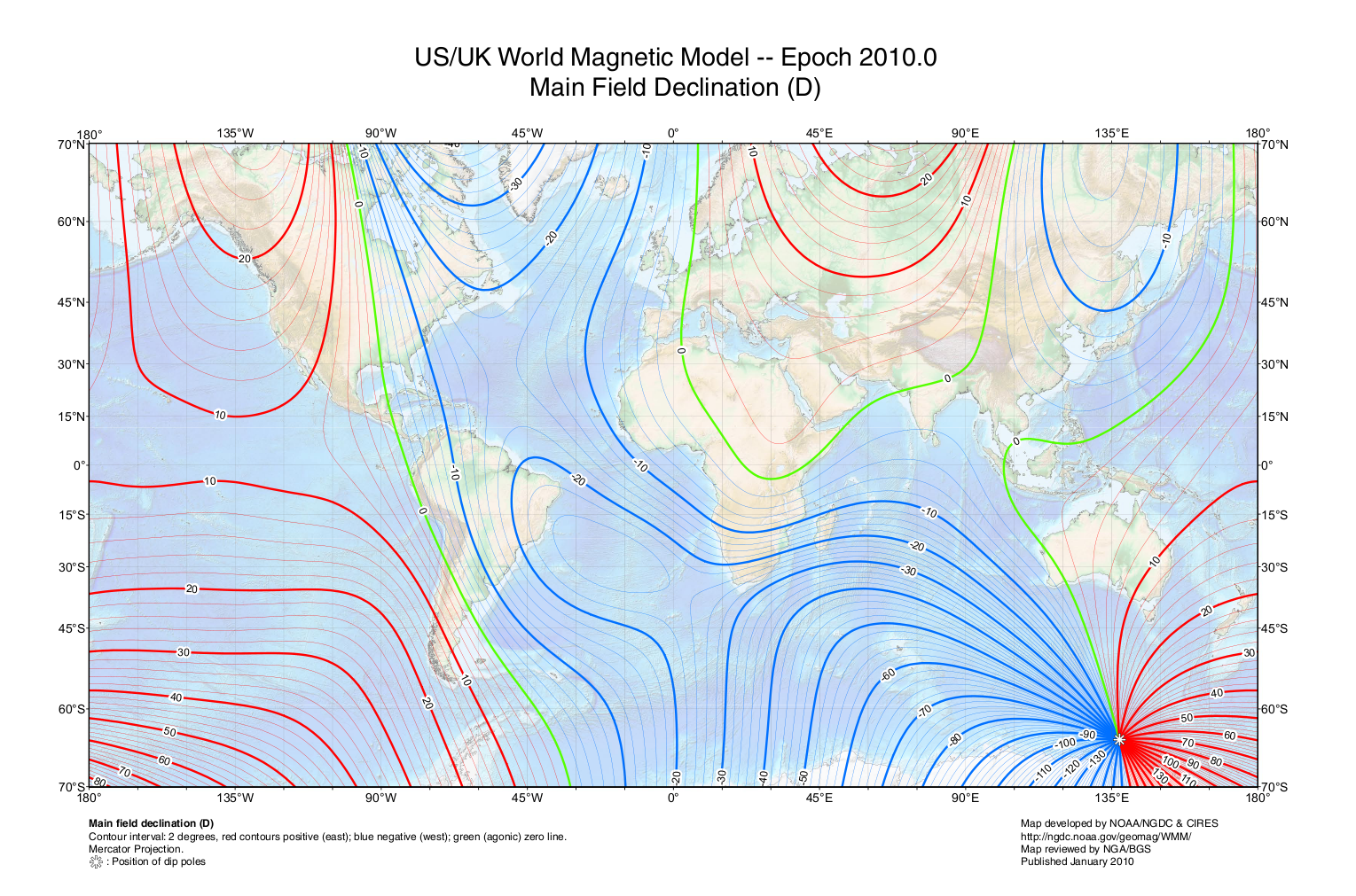
Given our latitude, Dec 9 2015 was calculated to be the day of The Earliest Sunset. Too many clouds. Dec 10 2015 was hazy with some clouds. I climbed The Hill To The North "Balanced" rock. The 33º S of due west on the phone compass app wasn't pointing at the sunset.
Time: 4:12; The bottom of the setting sun (orange spot in top center) touched the top of the far Blandford Hill. True sunset, when the top of the orb sank below the horizon, was 4:18.
The degrees on the phone compass was reading 254º? And fluctuating. ?
magnetic declination
Our early Sun Watcher didn't have a compass or know about "magnetic declination." He had many boulders along the long ridge to choose from. One, however, The Rock, had a level view to the western hills, where he could lean back against one particular slanted rock in the middle of a particular stone pile and face the setting sun. It was awkward. Rudimentary, but it worked.
Monday, December 7, 2015

Monday, November 30, 2015
Placed and curious stone features
 |
| A most unusual rock located near a Rock Pile. |
 |
| Side of one of two large standing rocks. Outer layer of rock chipped away in a manner that reminds one of a wolf or Wild Boar. Inbetween the two standing rocks is a large round quartz rock. |
Updated Photo: October 2017; Damaged by Logger. He actually tried to run them down.


 |
| Grooves worked in between two large slabs of rocks, one on top of the other. |
 |
| A rock, split, with two thin "points" from the same rock, set in a curious position. |
 |
| A Cairn in the woods. |
 |
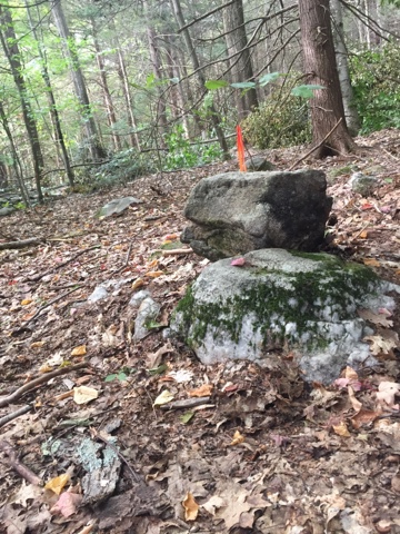
| A curious hole drilled in a boulder, which is located in an array of larger glacial boulders. There didn't appear to be a reason for this one boulder to be drilled. |
 |
| A Sign Post in the Woods. The ribbon marks a property line surveyed out by the owner of the land, for development purposes. |
 |
| One of several curious rock placements in the woods near my house. |
Sunday, November 22, 2015
Overlooking The Spring
 |
| This was spotted on todays hike; we were having to climb over rocks the size of trucks in an almost inaccessible area located above "The Main Spring." This three to four foot shaped standing stone is wedged between a two huge boulders. This is well off the usual hiking trails or logging tails; it's at the top of a Glacial Dump of gigantic proportions. There are rock caves suitable for bear dens. And the area certainly suitable for rattle snakes. Each year we have at least one new bear cub, and it's Mom, passing by the trail camera located 1/4 mile away from this spot. |
Rock Pile, Directional Rock or Bear Effigy Stone?
 |
| This is located near the Rock Cave. Looks like a Bear Effigy to us. Close up signs of flaking on the "face," and under one of the eyes. I pulled the woodland debris away from the base to see how many rocks were piled about; just two! Love the paws! |
Saturday, November 21, 2015
The Northern "Balanced" Rock Location
 |
| Standing Stones with white quartz in center. There is at least one foot of woodland debris surrounding them. |
 |
| Using The compass app to locate the expected alignment of the "earliest sunset" theory. December 8th, 9th and 10th, weather permitting. |
 |
| The compass needle kept "jumping around!" I had two iPhones with me, so tried the other one. No help; neither one would agree on "True West." You can see the North "Balanced" Rock at 12 o'clock in the distance. The closer boulder proved to be the spot I was searching for. Next concern; where along the Rock would one "focus" attention at the crucial moment. This "Balanced" Rock doesn't have a distinctive notch like the Southern "Balanced" Rock does. There was a slight notch on the north facing corner, and close-up I could see some interesting pecking. From the west, it suggested a face. Walking around to the east side...the pecking was even more distinctive, especially under the "chin." Is this for real? |
 |
| A Handsome head and shoulder portrait...about12 inches tall! |
 |
| And On the west facing corner: More pecking. A Fish? Who was this artist? Was he the same fellow who put a sliver of rock in the "mouth" of the Razor Back Turtle for a tongue? The one who pecked out the "eye" on the Bird Effigy? The one who created the bear effigy near the spring? Were they all of the same generation, or created over many seasons and years? The key positions for the sun are the two solstices and the two equinoxes, and for the moon the positions of the full moon closest to the two solstices at the times of the standstills. The easiest way of defining and recording such events for a society with no writing or instruments is by erecting permanent markers which cause a viewer to look towards the positions on the horizon where the sun or the moon will rise or set at the times in question. It is now accepted that this is part of the purpose of many of the standing stones, stone circles and chambered cairns erected in the late stone age or Neolithic period, and in the early Bronze age. |
Friday, November 20, 2015
Bent Tree Trail
 |
| Going where it leads.... |
On an old path, on a hill, overlooking The Lake,
An Old Bent Tree, points west. To the west, The "Balanced" Rock.
Was the "Balanced" Rock a Sunset Watching Spot? The Rock faces the setting sun. About 40 feet back from the Rock, a large circular Rock Pile. Near the center of the pile, a short standing stone.
" Winter solstice was of particular interest to many pre-technological cultures. Because the Sun rose and set at a very southern/low point, people were concerned that it might continue its southward journey, hence leaving the Earth in darkness. Ceremonies were held to encourage the Sun to resume its journey northward, or to celebrate the change to longer days."
The earliest Sunset at our Latitude occurs about 10 days prior to the time it sets on the Winter Solstice. On our modern calendar, at our latitude of 42• that date is December 8 & 9, 2015.
An early "sun watcher" wouldn't have a time piece, smart phone or calendar. This shift wouldn't be obvious, so simpler methods were devised." Therefore, we might expect that every evening following the Full Beaver Moon, Sun Watcher will be found sitting in the same well-marked spot. (Full Beaver Moon this year is Nov 25, 2015.
Now, if this "Balanced" Rock and adjacent Rock Pile (A Prayer Rock Pile?) are a Sunset Watching Spot, the setting sun should be directly in line with the Rock and one of the viewing spots at the Pile of Stones. There are several stones arranged in the larger pile; one is a square standing stone.
Read here for an explanation.If the sun is going to change it's direction, as far as The Sunset Watcher at this particular site is concerned, it will stop traveling further south when everything is in alignment , about 15 days after the Full Beaver Moon. "Let the Winter Solstice Ceremonies Begin!"
So that's my theory. I've made a plan. Beginning twelve days after the Full Beaver Moon, I will sit on The Stone, and point my camera at the "Balanced" Rock, (33• south of due west on a compass), and photograph the moment the sun "sets" on the line of hills far to the west. (Lots of trees in the way, but if there are no clouds, it will work. )
Just saying. (Or, maybe, just trying to listen. )
 |
| Bent Trail Tree. |
Subscribe to:
Posts (Atom)